Climate models are computer programs that simulate processes in the Earth’s climate system using physical laws and equations that have been mathematically programmed. They allow scientists to test hypotheses, explore future climate scenarios, and understand how different factors (like greenhouse gases) influence the planet. Models can range widely in scale and complexity and large models (often referred to as Earth System Models) simulate planetary patterns and long-term changes. Their results support everything from global climate assessments to local planning decisions.
All information given here is collected through individual contributions from ESMO SSG members and other participants. If you would like to suggest some additions or contribute to the page, please do so using this googledoc.
https://docs.google.com/document/d/19o3JN-AW8BfKt3H5vKQKNsYH7O_6YpJtmWDicRjMlgY/edit?usp=sharing
If you are not able to access the googledoc, you can send your suggestions over email.
CMIP
The Coupled Model Intercomparison Project (CMIP) is a collaborative project from the World Climate Research Programme (WCRP) providing climate projections to understand past, present and future climate changes. Its main goal is to improve our understanding of past, present, and future climate by comparing how different models simulate key processes and respond to various forcing scenarios (like greenhouse gas increases). CMIP and its associated data infrastructure have become essential to the Intergovernmental Panel on Climate Change (IPCC) and other international and national climate assessments. Each phase of CMIP (e.g., CMIP5, CMIP6) introduces updated experiments and protocols to reflect advances in science and policy needs. By using common inputs and diagnostics, CMIP makes it easier to evaluate model performance and understand the sources of uncertainty in climate projections.
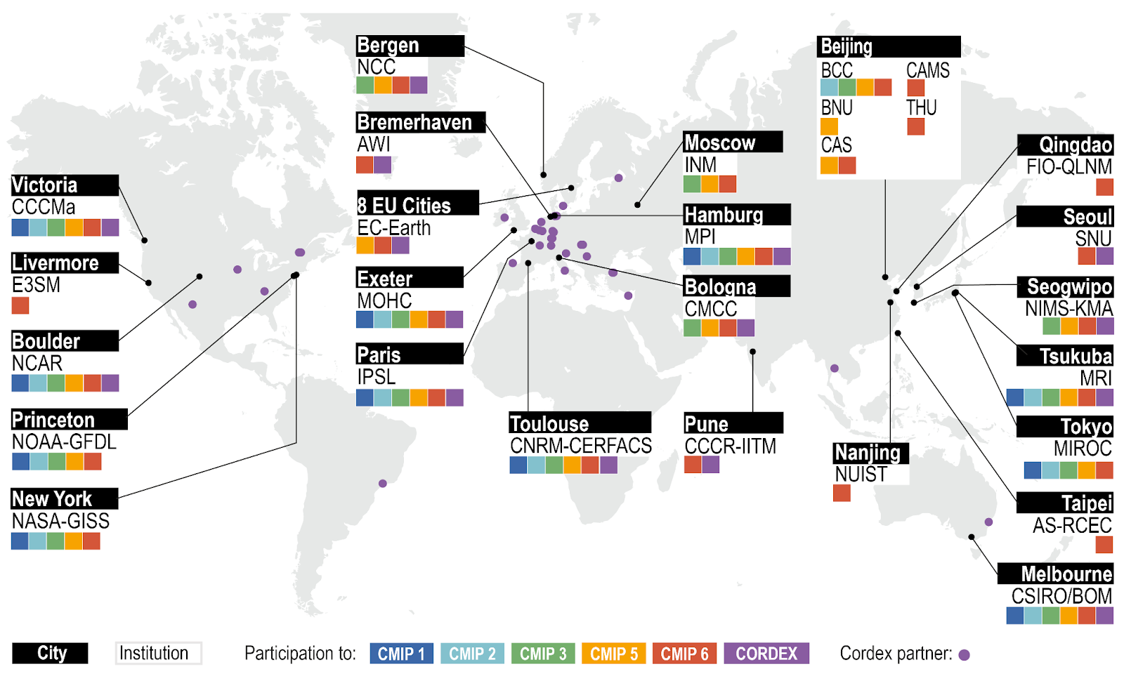
World map showing the increased diversity of modelling centres contributing to CMIP and CORDEX.
Figure 1.20 in IPCC, 2021: Chapter 1. https://www.ipcc.ch/report/ar6/wg1/figures/chapter-1/figure-1-20
doi: 10.1017/9781009157896.003 .
Important Data links and catalogues
- Earth System Grid Federation (ESGF) - The primary data portal for accessing CMIP (Coupled Model Intercomparison Project) simulations and other model output data from various modeling centers.
- World Data Center for Climate - Repository of several climate model datasets, hosted by DKRZ; part of the WMO/ICSU data system.
- IPCC Data Distribution Centre (DDC) - Hosts a subset of model output used in IPCC assessments, along with observational and socioeconomic data.
- Copernicus Climate Data Store (CDS) - Offers free access to a wide range of European climate data, including forecasts.
- ..
Other resources
Fresh eyes on CMIP guide for Dummies
The fresh eyes on CMIP team have put together some valuable resources to understand and utilise CMIP data.. (link not out yet)
Important Modeling related terms
These are some concepts that are specifically important in relation to climate models:
- Grid Resolution - The size of each grid cell in a climate model, typically in kilometers. Higher resolution means finer spatial detail but also higher computational cost.
- Boundary Conditions - Fixed values or inputs (like greenhouse gas concentrations or land surface properties) provided to models to define the simulation environment.
- Spin up - An initial run period used to bring the model’s internal variables into a stable state before analyzing results. Especially important for long-term or Earth system simulations.
- Parameterization - A method used to represent small-scale processes (like cloud formation or turbulence) that can't be directly resolved in climate models. These are estimated using simplified equations.
- Tuning - The process of adjusting model parameters to better match observed climate without compromising physical consistency.
- Coupled Model - A model that links different parts of the climate system—such as atmosphere, ocean, land, and sea ice—so they interact dynamically during the simulation.
- Ensemble Simulation - A set of model runs used to explore uncertainty. Can vary in model physics, starting conditions, or forcing scenarios.
- Climate Sensitivity - A measure of how much the Earth’s temperature would eventually rise if CO₂ concentrations doubled. Often used to compare how responsive different models are to forcing.
- Internal Variability - Natural fluctuations in the climate system that occur without changes in external forcing—like El Niño or the Pacific Decadal Oscillation. Distinguished from forced changes (e.g., due to CO₂).
Further information
Overview of model output
Model output can be of various types, based on the actual variables being modeled, the simulated time and spatial coverage. In general, it is helpful to keep the following in mind.
Type of model / simulation:
Models range from single column, imaginary boxes to detailed simulations of the global climate system. In general models focus on one specific component of the planetary system (ocean, atmosphere, land surface, etc). Several components are then coupled together to derive the state of the whole system. What we call a model can so denote either the individual components, or in some cases the entire coupled system.
In general we are interested in Global Circulation Models (that are attentive to large scale oceanic and atmospheric circulation patterns) or even Earth System Model, which include not just components of the physical world, but also biological systems. Many of the ‘CMIP type models’ are, therefore, ESMs.
Temporal coverage:
Models are generally ‘initalised’ (or started to run) at a specific stated time. Then as it evolves, the future predictions can show the evolution at different lead times (measured in specific time-steps). Different combination of initialisation time and lead time must also be paid attention to. In general, a model ‘drifts’ away from the initial conditions (generally based on some observation) at increasing lead times. These lead times ranges depending on their purpose:
- Synoptic timescales (hours to days, weather scale events)
- Seasonal (or sub-seasonal) forecasts (weeks to months ahead, often called S2S),
- Decadal predictions (1-10 years) and
- Long-term projections (decades to centuries).
Shorter lead times generally allow for more accurate predictions as initial conditions play a larger role, while longer lead times focus on forced climate responses where boundary conditions and external forcings (like greenhouse gas concentrations) become more important than initial atmospheric states. In climate studies, we consider the long scale evolution of the planetary system. As particular attention is paid to the effects of large scale industrialization, it is common to initialise the model around 1850 or 1900. The period from then until now, for which we have observational records, can then be used to assess how well the model performs.
One last bit - while the models might run in time steps of hours or days, the data output may later be saved differently, either by taking snapshots at particular moments, or by averaging the state over a day, month, or season.
Spatial coverage and resolution:
Climate models divide the Earth's surface and atmosphere into a three-dimensional grid of cells where equations are solved. The spatial resolution refers to the size of these grid cells, typically measured in degrees of latitude/longitude or kilometers. Global climate models (GCMs) provide worldwide coverage but historically operated at coarser resolutions of 100-300 km due to computational constraints. Modern high-resolution models can achieve 25-50 km globally, while some experimental configurations reach 10 km or finer.
Resolution directly impacts which physical processes can be explicitly represented versus requiring parameterization. Coarser models must parameterize phenomena like convective storms, mesoscale eddies, and topographic effects, while higher resolution models can resolve these features more directly. The vertical resolution—the number of atmospheric or oceanic layers—is equally important for capturing phenomena like boundary layer dynamics, cloud formation, and ocean stratification.
Regional climate models (RCMs) offer an alternative approach, using high resolution over a limited area of interest (such as a continent or ocean basin) while being driven by boundary conditions from global models. This allows detailed representation of regional features like coastlines, mountains, and land-use patterns at 10-50 km resolution without the computational burden of global high-resolution simulations.
The choice of spatial coverage and resolution depends on the research question. Global coverage is essential for studying large-scale circulation patterns and teleconnections, while regional focus with higher resolution is preferable for impact studies requiring detailed local information, such as water resource management or extreme weather analysis.